 |
| NH 6878 4549 (orig location, Pub.) NH 68789 45075 new location GPS 40min. | Diameter (orig) - 17.7m (Pub.) |
| Visited July 2010 | Alt.24m OD New location (GPS.) Old site 20m (Pub.) |
|
|
|
|
|
|
|
|
|
|
|
|
|
|
|
|
Photo Gallery |
VR Tour |
3D Vision |
Infrared Photos |
Rock Art |
Antiquarian |
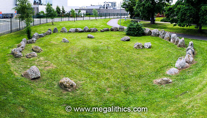
Stoneyfield ( INV 47 ), also know as Stoneyfield of Raigmore, Raigmore Cairn and Achnaclach, is a multi-phase monument of which the most obvious element is a ring of massive kerb stones which are size and height graded in the manner of the Clava tradition. It has been relocated, but both the original and new sites are on the NE outskirts of Inverness.
PUBLISHED ACCOUNTS
Richard Pococke, the Bishop of Meath, visited Stoneyfield in 1760 (1), he observed two circles at the site and commented on the similarity of the dual monument arrangement to that which he saw at Cullearnie, "I saw two such Druid Temples in the way to Culloden house as those in the way to the Fort, and exactly in the same position ; the place is from them called Stony field.". A footnote identifies the circle and the fact that the neighbouring monument has since been destroyed, sadly, another similarity to the Cullearnie rings, "Stoneyfield of Raigmore. There is only one Circle there now".
Anderson (2) mentions Stoneyfield briefly in his 1831 survey of cairns and stone circles in the Inverness region, "In some of the structures in this neighbourhood, a ditch or hollow, more or less complete, occurs between the outer and second circles, and the latter is sometimes formed of earth heaped up into a mound, without any upright stones. Somewhat of this description is the temple at Achnaclach or Stoneyfield, one mile east of Inverness.". There is no remaining evidence for a surrounding stone circle at the site (see later), which matches Anderson's account, but the ditch and encircling mound structure he describes sounds more like a henge monument.
The monument (and its neighbour) are mentioned in the New Statistical Account of 1845 (3), "a beautiful Druidical temple ; and many similar structures, now partly destroyed, exist in the parish of Inverness, as, for instance, on the plain of Culloden and at Stoneyfield, a farm so called from having two of them on its surface."
Fraser (4) goes to the trouble of publishing a very detailed plan of Stoneyfield and then fails to give any details of the monument at all in the text of his paper. He dismisses Stoneyfield and several other cairns by saying that his diagrams of them "show nearly all that can be said regarding them.".
Henshall covers Kinchyle in her magnum opus of 1963 (5) using Fraser's plan drawing. Stoneyfield is then relegated to a one-line comment in an appendix in her later work on the Central Highland cairns (7) in 2001.
Perhaps the definitive work on Stonyfield is
Simpson's paper of 1996
(6)
which details the excavation of the site in 1972-3, after
which the kerbs were relocated to the new site.
DESCRIPTION
The most important consideration when viewing our material on Stoneyfield is, that it is all of the monument in its relocated position, we have no material showing Stoneyfield in its original location as the relocation occurred in the early 1970's.
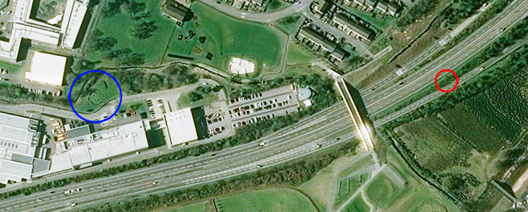
The original site of the cairn was only 500m south of the shore of the Moray Firth, the new location is a further 410m to the south. The relocation was necessary as the monument lay in the path of the A9 road building scheme and although it seems that care has been taken to recreate the layout of the cairn accurately, we think that the present location in a modern industrial estate, is not the best.
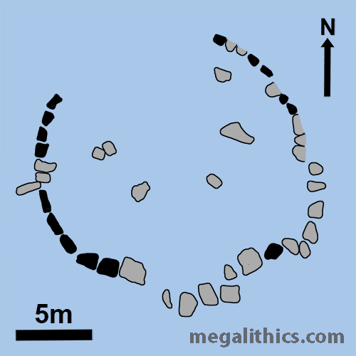
The monument is a large ring (17.7m) of massive kerb stones, the stones are height and size graded to emphasize the SW and this identifies the monument as being of the Clava tradition. Henshall (5) states that the tallest stone in the original monument was 1.45m high, this particular stone is set lower in the refashioned circle and the tallest is now two stones to its south, we measured this one at 1.18m high.
The tall SW quadrant was most intact with only three fallen kerbs, but the NW quadrant was totally missing and the eastern half of the ring had more fallen and displaced kerbs than erect. It looks as though many of the fallen kerbs have been re-erected at the new location, and the gap at the NW is considerably smaller in the new ring. The six stones that lay in the circle interior seem to have been relocated faithfully. It also seems that the re-builders even reconstructed the cists in the circle interior and marked the position of the timber structure (see later) with wooden posts, although there is no trace of these today.
Pococke (1) and the NSA (3) both speak of two circles at the site, but Anderson mentions only one in 1831, there is no mention of the second site in the excavations of the 1970's and we do not know if an attempt was made to locate any remains before the road was built.
Simpson's excavation (6) revealed that the site at Stoneyfield had been used over a long period of time and the kerb cairn monument was evidence of only one phase of this usage. Soil sampling from below the in situ stones showed that the ground occupied in the original location had been cleared and under cultivation for a considerable time before the kerb ring was erected. There seems to have been three phases of use at the site (not counting cultivation).
Phase one involved the digging of a number of pits some time in the early third millennium BC about 3600 CAL BC. A cup-marked stone was found in one of these pits and Grooved Ware in another.
Phase two involved the digging of more pits, some again containing Grooved Ware and one, the cremated remains of two adults and a tranchet flint arrowhead, this activity was dated to 2900-2300 CAL BC. A structure of wooden posts appears at the centre of the site about this time. There were at least 52 posts and the structure was roughly rectangular, approximately 10m by 5m. At its centre, the wooden structure contained a rectangular hearth constructed of sandstone slabs. This arrangement suggests a domestic purpose for the structure, but fragments of bone recovered from the hearth and some of the postholes may be human, which would suggest a ritual, perhaps funerary, purpose. The ring of kerb stones with Clava type size gradation and the platform cairn within them was built during this phase, but after the construction of the wooden structure. The wooden structure and hearth appear at the exact centre of the kerb ring. There is, however, no direct conclusive evidence for the date of the kerb cairn building.
Phase three saw a series of four cists being built in the interior of the ring, one of which contained a Food Vessel. A large pit was also dug through the cairn fill and this contained a cremation of a child of 3-4 years of age under an inverted Cordoned Urn. Dating for this phase is 2300-2000 CAL BC.
The kerb stones were not set in stone holes, they were deposited directly on the surface. This finding would suggest that if a surrounding stone circle existed, its stones too may have been surface set. If the circle was later removed in antiquity, there would, unfortunately, be no stone holes remaining to show it had existed. The interior of the kerb ring was not filled with a mound, and it was found that the cairn fill did not cover the entire internal space. There seems to have been a circular central "platform" of cairn fill and several other small mounds dotted about inside the ring, in no area was the fill deeper than 0.4m.
A substantial amount of fill was also deposited against the outside of the kerb stones, presumably as revetment to stabilise their unsocketed condition. This external material is seen particularly against the huge kerb stones of the SW quadrant, but puzzlingly there is no material supporting their inner sides, indeed, the unsubstantial central cairn stops long before reaching these stones.
The Stoneyfield cairn remains something of a puzzle, the height graded kerb emphasising the SW suggests a Clava tradition monument, but if this were a mainstream Clava structure of this size, it would most likely be a ring-cairn. It also has some similarities to the cairns found within the recumbent stone circles of Aberdeenshire, but these also too tend to be, in essence, ring cairns. There are kerbed cairns within the Clava tradition, indeed, there is one at Balnuaran itself, but these are small diameter monuments with disproportionately large kerbs for their diameters. It is shame that Stonyfield's now-vanished sister site had not survived, examination of its characteristics may have shed some light on the possible derivation of this puzzling monument.
1.
Pocoke, R., "Tours in Scotland
1747,1750,1760", p.104, Edinburgh University Press, 1887.
2.
Anderson, G., Archaeologia Scotica,
3, p215,1831.
3.
The New Statistical Account of Scotland, 14, p.15, 1845, Edinburgh.
4.
Fraser J.,
Proceedings of the Society of Antiquaries of
Scotland, 18, p.356-8,1884.
5.
Henshall, A. S.,
The Chambered Cairns of Scotland,
p.384-5, Edinburgh University Press, 1963,
Edinburgh.
6.
Simpson, D.D.A.,
Proceedings of the Society of Antiquaries of
Scotland, 126, p.53-86,1996.
7.
Henshall, A. S. and Ritchie J. N. G., The Chambered
Cairns of the Central Highlands, p.225-7,
Edinburgh University Press, 2001, Edinburgh.