 |
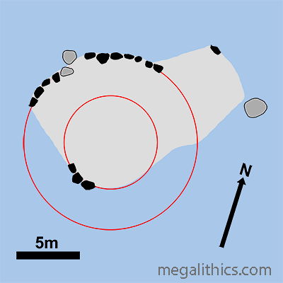
| NH 72509 47689 (GPS 31min) | Diameter 13.5m Outer kerb, 21.7m Stone Circle (Est.) |
| Visited June 2010 | Alt. 30m OD (GPS) |
|
|
|
|
|
|
|
|
|
|
|
|
|
|
|
|
Photo Gallery |
VR Tour |
3D Vision |
Infrared Photos |
Rock Art |
Antiquarian |
Cullearnie ( INV 23 ), also known as Cullernie, Upper Cullernie and Culloden Tileworks, is an extensively robbed and ruined Clava Ring-Cairn. The cairn is situated in pasture land about 2.5 km North of Culloden on the south side of the A96. The Moray Firth is only around 3km to the west and is visible from the site, the Clava Ring Cairn Newton of Petty lies 3.5km to the NNE.
PUBLISHED ACCOUNTS
There is very little coverage in the
literature regarding Cullearnie. The most extensive early account is by Anderson
(1), he visited the site in the 1820's and the site was obviously in a much
better state of preservation then. He describes "two concentric circles, and
part of an inner one", the partial inner and mid circle would be the inner and
outer kerbs of the ring-cairn itself, whilst the outer ring was the stone circle
that surrounded the cairn and places this monument firmly within the Clava
tradition. Anderson puts the stone count of the outer circle at
15, but the number for this type of monument is usually between 9 and 12. His
plan of the site shows these outer stones with very atypical irregular spacing,
so there may have been some disturbance even then. He describes the average
height of circle stones to be 3 feet with two 5 foot high stones at the NE, two
much larger stones were fallen at the SW, which would fit well with the usual Clava height grading toward the SW/SSW.
The inner ring kerbs had been extensively robbed and the only contiguous run was
of 4 stones at the west, the 3 contiguous stones presently standing there are
most likely survivors of these 4. There were enough inner kerbs extant during
his visit for him to state that the diameter was about "seven to eight paces".
Anderson puts the outer kerb stone count at 34-36, with the smallest stones at
the east, again fitting with the typical Clava SW height bias. Even then, in the
1820's many of the outer kerbs were fallen.
He also describes a neighbouring site close by, with a kerb "15 paces" in
diameter, but this time encircled by a ditch and not a stone circle. Sadly,
there was no trace of this cairn visible during our visit.
Richard Poccoke, the Bishop of Meath observed
Cullearnie in 1760 (2), "I passed by two Druid
Temples, one of them like that described before I came to Inverness ; the other
about 100 yards East of it, not having the Outer Circle of Stone". Sadly the
neighbouring monument, almost certainly a second Clava cairn judging by his
description, has since been totally destroyed. In cases like this we often
wonder what quirk of fate preserves one monument, and then dooms another, only
100m apart.
In 1884 James Fraser published a study (3) of 39 Invernesshire "stone
circles", many of which were obviously ring-cairns. Cullearnie is named as
"Culloden Tileworks" in his listing, but he does not even deign to mention it by name in the
text lumping it together with 12 other sites of which "very little can be said,
as they are generally in a very fragmentary condition". Interestingly, the next
circle in his list is "Cullearnie (east end)" perhaps the now-vanished
neighbouring cairn described by Anderson.
Similarly, Burl (4) has little to say about
Cullearnie in his comprehensive work on stone circles, save that its cairn plan
was "simply irregular". This comment may be due to difficulty in interpreting
the current ruinous and modified state of the cairn in modern times, and not a
true reflection of its original form.
Cullearnie is, of course, covered in Henshall's opus (5) (or as we like to call it, "The Bible"), and in her later, excellent and more detailed account (6) of the Highland Cairns.
We could find no reference of any excavations at the site, and presume it is still unexcavated.
THE CAIRN
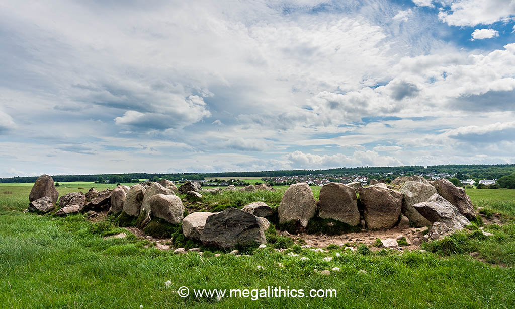
The monument has been extensively robbed and savaged over the years and this makes it difficult for the modern visitor to interpret the original structure from what remains. This is probably why no two plans of the site agree exactly and even the most modern are slightly at variance with what you can see there today. Currently, there is a roughly rectangular mound (light grey area in site plan above) that we measured at 15.5m NE-SW and 11m NW-SE, we could not measure the height accurately, but the outer kerbs are about 1m tall and the mound is lower than these. The ruination and lack of excavation makes estimates of the original dimensions of the monument difficult, but extrapolating perfect concentric circles form the remaining in situ stones gives diameters of around 7m for internal space, 13.5m for the outer kerbs and 21.7m for the surrounding stone circle.
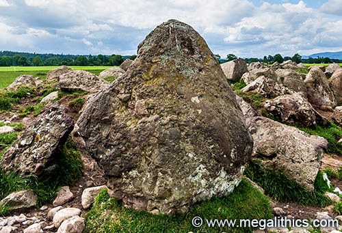
As well as the widespread damage, field clearance stones have been extensively dumped on the monument causing the anomalous plan we see today. Henshall (6) suspects that many of the larger stones visible are in fact fragments of the circle stones that used to ring the monument, some showing evidence of intentional splitting. A line of these large stones forms a kind of revetment on the NW side of the present mound fusing the west end of the intact outer kerbs to the north end of the surviving inner kerbs into one confusing row. These stones cause much of the problems whilst trying to interpret the monument's original form today.
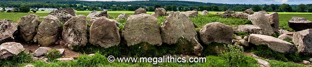
The most striking feature of the site today is the surviving arc of outer kerbs stones at the NW, these stones are around 1m tall and have flat outer faces, their contiguous edges are straight and well fitted together. The arc is continuous except in the middle where two kerbs have fallen forwards, the field is pasture so livestock using the kerbs for shelter have eroded the soil, exposing their bases and making them prone to collapse. The outer kerb seems to have had a diameter of about 14m, but this assumes an original circle (see plan above) and is an extrapolation from surviving stones.
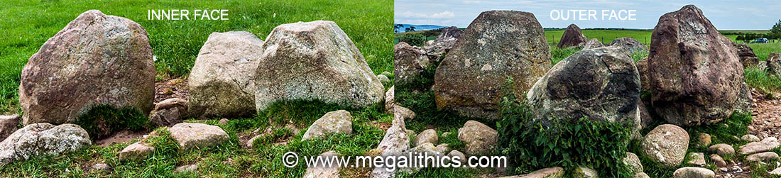
All that remains of the inner kerbs are three stones standing at the SW. Although these are shown in plans and described as a continuous arc, the central stone has fallen backwards and is no longer in line. As the cairn material behind the stones has been removed the rear faces of the kerbs are now visible, it is very apparent that the stones were selected for the flat faces that would have faced into the central space of the ring-cairn, as the now-visible rear faces are very uneven (see photo above). The diameter of the space delineated by the inner kerbs is calculated to be about 6.5m, again, this is an estimate based on what remains, and also supposes a true circle.
A lone survivor of the stone circle that once surrounded the cairn stands at the NNE, this is a diamond-shaped slab of Puddingstone standing about a metre tall and 3-4m outside of the extrapolated ring for the outer kerbs. As with the inner kerbs, one face of the standing stone is very flat compared to the other and the stone has been set with the flat surface facing the cairn. Another circle stone lies fallen about 4m away to the SW, it would have been similar in height and is also comprised of Puddingstone. Anderson described the circle as having fifteen stones, we extrapolated a circle from the two surviving stones, and assuming that the fallen stone had not been displaced, the distance between the two stones stepped out around the circumference produces almost exactly a thirteen stone ring. Presumably excavation could find the stone holes, and this is probably the only way the true stone count could ever be known. Rather infuriatingly, it seems that nearly all of the circle stones were standing during Anderson's visit in the 1820's, but by 1880 all but two had been removed :O(
Although ruinous, we found this site quite attractive, perhaps because of all it has suffered so recently. We have visited many Clava Ring-Cairns in much better states pf preservation and this must have been a spectacular example before it was ruined. As mentioned above, the site is only about a hundred metres from the A96, and there is a handy parking bay close by.
1.
Anderson G. Archaeologia Scotia, 3, p.211-22, 1831.
2.
Pocoke, R., "Tours in Scotland
1747,1750,1760", p.104, Edinburgh University Press, 1887.
3. Fraser J.,
Proceedings of the Society of Antiquaries of
Scotland, 18, p.328-61,1884.
4.
Burl A.
The Stone Circles of Britain, Ireland and Brittany,
p.235-6, Yale University Press, 1979,
Newhaven & London.
5.
Henshall A. S.,
The Chambered Cairns of Scotland,
p.372-3, Edinburgh University Press, 1963,
Edinburgh.
6.
Henshall A. S. and Ritchie J. N. G., The Chambered
Cairns of the Central Highlands, p.217-8,
Edinburgh University Press, 2001, Edinburgh.