 |
| NH 48843 56536 (GPS 68min) Inner chamber | |
| Visited June 2010 | Alt.185m OD (GPS) |
|
|
|
|
|
|
|
|
|
|
|
|
|
|
|
|
Photo Gallery |
VR Tour |
3D Vision |
Infrared Photos |
Rock Art |
Antiquarian |
Ballachnecore ( Ros 3. ) is an extensively ruined cairn with an Orkney-Cromarty type chamber. The cairn is situated 10km north of Inverness, on the spine of a spur running west down to east.
PUBLISHED ACCOUNTS
Stuart (1), briefly mentions Ballachnecore in his antiquities survey of 1868 while describing the vitrified wall at Knockfarril, saying only "On the same ridge there was a cairn, of which the two ruined chambers alone remain".
In 1944 Childe (2) included Ballachnecore in his survey of "An unrecognised group of chambered cairns". Listed as No.12 he noted the polygonal nature of the inner compartment, but described the remains of the outer compartment as being those of an entrance passage. He published a very good plan of the site, which included the tree near the lintel stone, this has since been felled and can be seen in our photos a stump. Childe saw the northernmost stone of the outer compartment as not being part of the chamber structure and lumped it in with the external stone at the south saying "The function of two stones outside the construction cannot be determined.". He was not aware of the external stone at the SE.
Ballachnecore is, of course, covered in Henshall's magnum opus (3) of 1963, and then again, in expanded form, in the later update of this work (4) of 2001. She mentions that the cairn "is traditionally said to be the spot where a number of the followers of Brodie of Brodie were interred having been slain at the Loch na Parc in a conflict with the Macdonalls of Glengarry at the latter end of the 15th century". In her 1963 work she considers, as did Childe, that the outer compartment was in fact an entrance passage, but sees it as a true outer compartment with a now-vanished passage in her later work.
We could find no reference of any excavations at the site in any of the above works, and presume it is still unexcavated.
THE CAIRN
The cairn is situated on a spur of the hill covered by Bellton wood. The land was in forestry use during our visit and was heavily planted, indeed, trees have obviously been growing n the cairn structure itself, Childe shows one in the chamber and we noticed the stump of this, and several others in the cairn structure during our visit. The location on the spur would give wonderful views over the surrounding countryside, but these are presently blocked by the plantation. When visiting sites such as this with panoramic views, we often wonder about the degree of forestation when the cairns were actually built, if the view was a factor in site choice, there must have been extensive clearance.
The location on the spur obviously limits the spread of the cairn N-S unless the mound was engineered to accommodate the fall off. Henshall (4) describes the ground falling off to the north steeply, but we found it fell to the south just as precipitously, so perhaps there have been recent earthworks here.
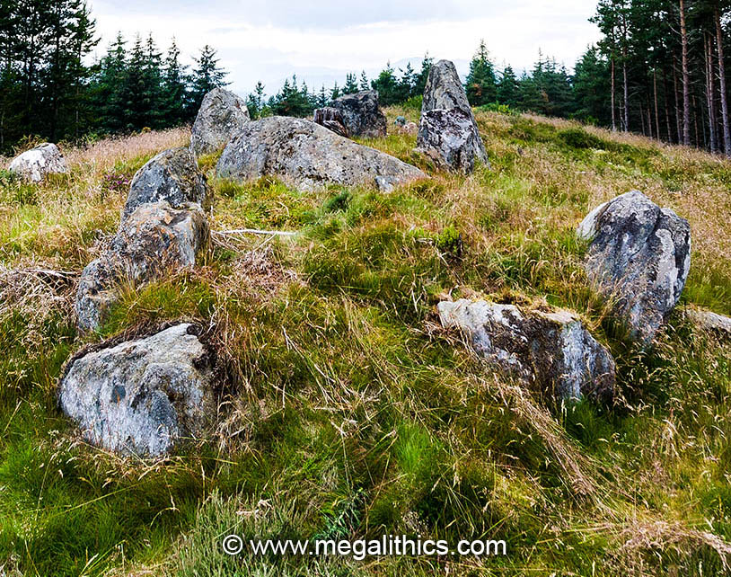
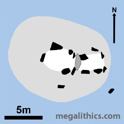
The monument is heavily damaged, most of the cairn material has been robbed away and some chamber orthostats are missing, although one original lintel still survives. The original cairn dimensions seem to have been around 13.5m by 10m with the long axis aligned to that of the chamber. As mentioned above, the topography of the site must have posed a problem for the cairn builders unless this has changed since their days.
There are surviving remains for a two compartment chamber with a now-vanished entrance passage, the structure is oriented E-W with the entrance at the east, as usual. The outer compartment is roughly rectangular, 3.5m long and 1.6m to 1.8m wide depending on whether the northern orthostat is included as a chamber element. The entry portal stones are about a metre apart and those to the inner compartment 1.2m apart. The structure shows the inter-chamber paired portal stone arrangement also seen at Heights of Brae, here a surviving lintel stone now lies between the pairs of stones.
The inner chamber is polygonal and comprised of four orthostats, although there was probably one, or two, more in the current gap at the south. The compartment is 7.8m long and 2.7m wide, the wall stones here are the tallest surviving at the site, the highest being the north stone at almost 2m high on its outer face. It is interesting that there seems to have been no importance placed on having an axial back-stone in the inner chamber, this is a constant feature of Camster type chambers, but is absent here and in some other Orkney-Cromarty chambers such as Heights of Brae.
There are two surviving stones outside of the chamber structure (not counting the oddly placed northern stone of the outer compartment), a prominent stone at the south, and an almost buried one at the SE. Both of these would have presumably have been buried under the material of the covering cairn, so their intended functions are unknown.
There is no direct vehicular access to the site and the approach is by tracks and rough ground, so probably not a one for mobility impaired folk.
1.
Stuart, J.,
Proceedings of the Society of Antiquaries of
Scotland, 7, p.301,1868.
2.
Childe, V.G.,
Proceedings of the Society of Antiquaries of
Scotland, 78, p.31-2,1944.
3.
Henshall, A. S.,
The Chambered Cairns of Scotland,
p.334-5, Edinburgh University Press, 1963,
Edinburgh.
4.
Henshall, A. S. and Ritchie J. N. G., The Chambered
Cairns of the Central Highlands, p.150-2,
Edinburgh University Press, 2001, Edinburgh.