|
|
Photo Gallery |
|
|
Panoramas |
|
| NX 383 565 (Pub.) | Diameter 20m x 19m (Meas.) |
| Visited July 2001 | No magnetic anomalies |
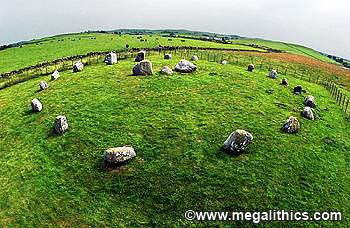
Situated about 5.5 km west of Wigtown, the Torhousekie circle has survived to the
present day in excellent condition. The circle has all nineteen of its original
circle stones and these stand on a circular artificial platform of earth
and small stones. The stones are height graded to the ESE and the stone spacing
is also graded, with the smallest gaps at the NW and the largest at the SE. As
well as the grading, the SE emphasis is further reinforced by a flattening of
the ring in this quadrant. The two tallest stones of the SE quadrant
(6&7), are particularly prominent, they are much less rounded than the other
circle stones and stone 7 has a number of unusual surface features, some with
quartz inclusions.
Within the circle is a "D" shaped rubble
bank about 8.2 x 9.4m, this feature is difficult to make out at the site today. The straight edge of the "D" is aligned SW-NE and therefore
"faces" the emphasized SE quadrant. Set on this straight edge are
three stones, the northern stone is about 1.1m tall and the southern would be
about the same height if it were not fallen, together they flank a much smaller stone
that stands about 0.7m high. Although referred to as a "central
construction" this three stone row is not actually at the centre of the
ring, because of the flattening of the circle it stands nearer to the stones of
the SE quadrant.
Aubrey Burl (1) points out the similarity of the central construction to the
recumbent and flanker trios of the recumbent stone circles (RSCs), of NE
Scotland and suggests that Torhousekie is a variant form of this circle class.
We think that this is unlikely as none of the RSCs show central constructions
and their grading usually emphasizes the SW quadrant with its lunar
associations. John Barnatt (2) also thinks that a link with the RSC tradition is
unlikely, pointing out the geographical separation and the frequency of other
central constructions in circles of the western region.
127m east of the circle at NX 384 565 stands a three stone row on a NE-SW axis,
it is said to be height graded to the SW and aligned on the midwinter sunrise.
Unfortunately our visit to Torhousekie was towards the end of an outbreak of
Foot and Mouth disease and the stone row (and most of the country!), was
off-limits so we were unable to get bearings or measurements.
There are accounts of an arc of three fallen stones to the NW at NX 382 566
which suggest these to be the remains of a second circle, although these stones
were removed before1932, they were were almost certainly a fallen second stone
row.
There are accounts of a boulder bearing a large oval hollow embedded in a
dry-stone wall18m to the east of the circle, we could not find this stone but
could only view the wall at a distance because of the Foot and Mouth
restrictions.
1. Aubrey Burl, A
Guide to the Stone Circles of Britain, Ireland and Brittany, 1995 Yale
University Press
2. John Barnatt, Stone Circles of Britain, B.A.R. 215(i) 1989, Oxford