 |
| NH 30681 12495 (GPS 5min) | Diameter - 30.7m x 32.2m (Pub.) |
| Visited June 2008 | Alt.5m OD (GPS) |
|
|
|
|
|
|
|
|
|
|
|
|
|
|
|
|
Photo Gallery |
VR Tour |
3D Vision |
Infrared Photos |
Rock Art |
Antiquarian |
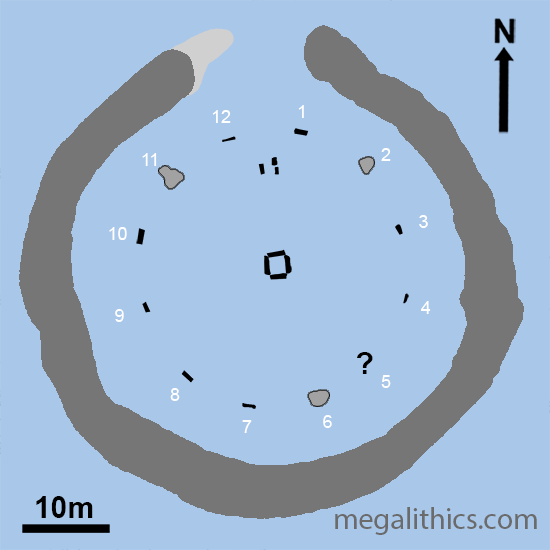
The stone numbering scheme used throughout these pages is that of Barnatt (ie. clockwise from north).
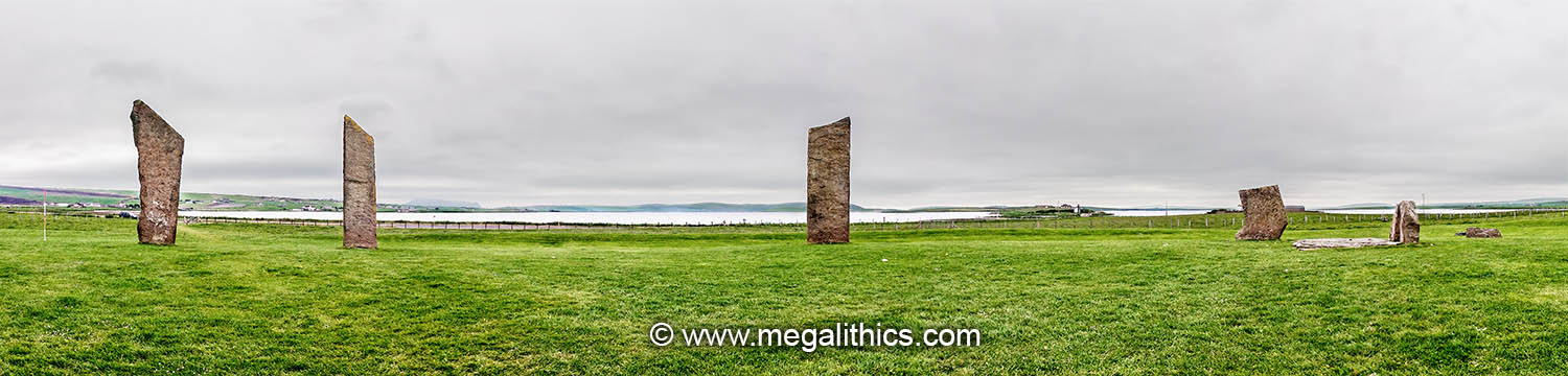
The Stones of Stenness, is large henge monument enclosing a stone circle and other stone settings. It is located on Orkney Mainland where the Lochs of Stenness and Harry meet, just SE of where the Bridge of Brodgar links the Stenness and Brodgar promontories. Although the circle is impressive today, having huge stones with a distinctive shape, the entire monument has been extensively modified, and also ravaged by the hands of time (and Capt. William MacKay!). As Orkney is a treasure trove of prehistoric megalithic monuments, the Stenness circle is close to, and intervisible with, several other sites of major archaeological importance such the Unstan cairn and the Ring of Brodgar. The name Stenness may come from the Old Norse "Stein-ness", meaning "stone headland", the stone part perhaps referring to the circle or perhaps, the Watch Stone.
PUBLISHED ACCOUNTS
Despite their prominence, we have noticed that some Orkney monuments have very few papers published in academic journals that are specific to the sites themselves. The vast majority of publications that mention Stenness are general works covering stone circles, henges, or Orkney prehistory as a whole, as these general works are literally countless, we will include only a few.
The earliest illustration, and earliest published mention, of Stenness we found is by Pococke (1) in 1760. He describes the circle as "15 feet high, six feet broad, the Circle is about 30 yards in Diameter, and the stones are about eight yards apart; There are two standing to the South, one is wanting, and then there are two standing to the West, a third laying down, then two are wanting, there being a space of 27 yards so that there were eight in all." This fits with later descriptions, the two at the south are stones 7 and 8, and at the west 10 and 11, the "third laying down" may be the large slab of the inner stone setting.
Pococke goes on to describe the outliers "Eighteen yards South East from the Circle is a single stone, and 125 yards to the East of that is another with a hole - in it on one side towards the bottom, from which going towards the circle is another 73 yards from the fossee, the outer part of which fossee is 16 yards from the Circle." His measurements and directions are confusing, but the holed stone he mentions is The Stone of Odin (destroyed in 1814, see later). There is no other record of the stone he mentions at 18 yards and curiously, it is not shown in his illustration unless it is a fallen stone shown there. Also shown in his illustration, but not mentioned in the text, is the Watch Stone.
His mention of the henge ditch (or fossee) is interesting, almost every trace of the henge ditch and bank had been obliterated through silting and .ploughing by modern times, it must have been very apparent in 1760 for him to comment on it. Cleveley also shows the earthworks in his illustration of 1772, but they are absent in Henry's 1774, Spottiwoode's 1802, and Leveson-Gower's of 1805 (for these illustrations see our Antiquarian page).
The Rev. George Low writes about Stenness in 1774 (2), "The drawing shows these stones in their present state, which is four entire, and one broken." The identity of the broken stone is unclear, probably not the remains of the stone setting as he possibly describes this later "several stones set on end without any regular order, or several of them being so much broken, hinder us to see the design of them.". "The drawing referred to in the quotation is not the Henry illustration included when Low's accounts were published in 1852 as "Tours", it was a sketch of Stenness made by Low himself which was lost after his death. Low also refers to Stenness as "The Temple of the Moon", but there does not seem to any other reference to this nomenclature in other literature.
Interestingly Low comments of Stenness that "It is not ditched about like the former, but surrounded by an artificial mound partly raised on the live earth. as the other was cut from it." which probably means that the henge bank was very prominent at this time, but the ditch had silted up ; "the former" he mentions in the quotation is the Ring of Brodgar.
Low also thought that Stenness was never a circle, "both the position of the stones and the surrounding work, show that the design has been a semicircle". He also describes the outlier, the Stone of Odin "a pretty broad stone broke from its original height, with a round hole cut through it, not in the middle, but to one side of it, very much worn as if by constant friction in tying anything by this hole". This stone was destroyed in 1814. He also mentions the Watch Stone, "at the end of the bridge a very large stone, equal to any in the semicircle".
In July1824 the ship "The Griper" sought shelter at Stromness after nearly being wrecked, which resulted in our favourite account (3) of the circle. The Captain, G.F. Lyon, states "I walked into the country to see some Druidical remains, situated at Stenhouse". Stenness had suffered serious damage at the hands of William MacKay by this time and Lyon reports this had not gone down well with the locals, incurring "the great chagrin of some of the old Orkney women, who hold these ruins in great regard". He goes on to describe the site, "three flat slabs of sandstone standing upright, and from ten to fifteen feet in height. One entire slab lay flat on the ground.............. The fallen stone had been embedded two feet and a half, and the space in which the four had stood was surrounded by the still visible remains of a mound, about thirty yards in diameter." This account shows that at least part of the henge bank was very apparent in 1824, and yet this feature was not included in the three earlier illustrations mentioned above.
Thomas (4) includes Stenness in his 1852 survey of "Celtic Antiquities of Orkney".
Detailed examination of the monument was not until 1973 and Ritchie's (5) extensive excavations. Most of the details in the account below come from this paper.
In more general surveys of specific monument classes, Stenness is, of course, covered in Burl's definitive work of 1976 "The Stone Circles of the British Isles" (6) and is listed as Site No. 289 in Harding with Lee's catalogue of henge monuments in Great Britain (7). Finally, Barnatt (8) gives a detailed description of the monument in his 1989 classification and catalogue of stone circles.
THE HENGE
Stenness had the usual bank and ditch characteristic of henge monuments, importantly with the bank on the outside of the ditch. It is a class 1 henge with a single causewayed entrance penetrating both bank and ditch at the north. In its original state the ditch was around 6m wide and about 2.3m deep, this is lower than the local water table and the ditch would have filled with water automatically. Remains of aquatic plants were discovered when the ditch was excavated, showing that the ditch had contained water for long periods of time. The ditch was not simply dug into the earth, Ritchie found that the bottom of the ditch had been cut into the bedrock 1m deep over 4m of its width, for people with no hard metal tools this must have been an arduous undertaking.
The ditch ends either side of
the causewayed entrance at the north, originally the gap here was about 12.8m,
but sometime after the ditch had been finished it was modified, the western end
of the ditch was extended narrowing the causeway to around 8.2m wide.
The ditch extension is shown in light grey in our plan diagram above, the
extension was narrow compared to the original ditch, more like a trench, and with
a pointed end compared to the rounded eastern ditch terminal. The
purpose of this modification is unknown, but it does shift the centre of the
causeway 5-6 degrees towards the north, which may have been significant to the
folk using the monument. Radiocarbon analysis of bones found in the main ditch bottom
gave a date in the range 2356 bc +- 65.
The ditch was surrounded by a bank but this has been almost totally destroyed by ploughing, so there is little evidence of its original dimensions. Ritchie found remains of the bank material in a ring about 6.5 wide, but this is probably not the original size as the ploughing would have spread the material, it is likely the bank was originally around 70-75m in diameter.
The ditch encircles a central area about 47m x 43m, the stones of the circle are set in this area about 5.5-8.5m from the ditch.
THE STONE CIRCLE
It is not clear which component of the monument was built first, there is an argument that the circle was built first as it would have been very difficult to haul the stones into place if the bank and ditch of the henge had been extant, but this is pure supposition, and there is no concrete evidence that this was the case. It would seem to us that if the rock cut ditch of the henge is anything to go by, the builders had no problem at all doing "very difficult".
The ring of stones measured 30.7m x 32.2m and it is likely that there were originally twelve stones, Ritchie found stones, stumps and stone holes for eleven uprights, but at the presumed location for stone 5 he found only a "sharp-sided hollow" which he describes as being "very slight" compared to the other stone holes he found. Considering the effort required to construct a monument of this size and complexity, it seems unlikely that the builders would willingly leave the ring unfinished, so the potential missing stone is a puzzle.
From the earliest accounts up to 1814 there were four stones erect at Stenness, presumably in their original locations, these were stones 7, 8, 10 and 11. Pococke describes a stone "laying down" and Low mentions "one broken" in addition to the four erect monoliths, it is unclear whether this was a fallen circle stone or some element of the internal stone settings. Unfortunately, Low's sketch of the stones, which would have resolved this question was lost after his death. Barnatt states that prior to 1814 the stones erect were 5, 7, 8 and 11, this cannot be true as Ritchie found that the probable location of stone 5 had virtually no evidence for a stone being there, also this arrangement would not fit with illustrations of the stones from this time.
In December of 1814 the tennant farmer of the land, Capt. William Mackay, began a systematic destruction of the stones. He toppled two stones, 10 and 11, both stones were drilled to receive gunpowder charges for blasting and stone 11 was destroyed by this method. Luckily the news of Mackay's deranged behaviour reached the local Sheriff and he was able to stop him before he could destroy stone 10. Unfortunately, the outlying stones were also in Mackay's sights and he had also completely destroyed The Stone of Odin before he could be stopped. It is unknown why Mackay took such a drastic path, just four months previous he had met with Sir Walter Scott, who admired the stones and went on to use the setting for his novel "The Pirate". Mackay used the fragments of the stones he blasted to build a cow shed.
Stone 10 languished in its fallen position until 1907 when it was re-erected. We frequently see the difficulty of stone raising being overstated in popular TV programmes, magical levitation, or help from UFOs is often suggested. Stone 10, 5.5m long and weighing 9-10 tons, was re-erected by just eight men using wooden cribbing to raise the stone and slip it back into its stone hole, although to be fair, it did take them two attempts!
During 1906-7 refurbishments by the Office of Works a stone was discovered buried, Magnus Spence (9) describes this "Near this fine monolith (stone 10) and within the circle was unearthed a large, ill-shaped stone". The shape of the stone was so odd compared to the surviving monoliths that there was much discussion about being a circle stone at all "Its shape and uncomeliness make one doubt what the position suggests". Eventually agreement was reached and the stone was "erected in the place indicated. Its end, we understand, suited the socket. We have doubts as to whether it is a genuine monolith. It looks such a dwarf amid these huge monoliths..... . Mr Cursiter considers it is the broken part of the original stone, which is a likely explanation". The buried stone was placed in the hole of stone 12 and set into a raft of concrete, which is how the bizarre boomerang-shaped stone 12 now stands in the circle.
INTERNAL STRUCTURE
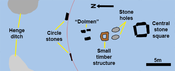
Before Ritchie's excavation the only internal feature known was a stone setting inside the stone circle at the north. This consisted of two upright stones aligned N-S and a large slab, it is represented in many early drawings, it is clearly visible in Cleveley's illustration done in 1772 (see our Antiquarian page). By the 1880's an idea became generally accepted that the stones were parts of a ruined dolmen, indeed, when Pitt-Rivers the Inspector of Ancient Monuments visited in 1885, he referred to the stones as "the remains of a dolmen". So, during the 1907 "refurbishments" a third upright stone was added at the west, the large slab was then placed on top of the tripod thus formed and a "dolmen" was created. The origins of the added stone are vague (as are many accounts of the stone setting itself), but it probably did not come from inside the circle. Unfortunately the builders of the dolmen dug new holes for the two eastern upright stones and set them both in beds of concrete, so any useful archaeology there was destroyed and their current locations may not be original.
The plan above shows the presumed original stone setting positions, two rows parallel to each other and orientated towards the causeway. It is a little confusing that the "capstone" slab was supposedly the western stone, the stone illustrated in this position seems much smaller. Although the "dolmen" was a totally spurious confection, it did serve a useful purpose. In 1972 unknown persons pulled the "capstone" off the dolmen and the damage thus inflicted was the stimulus that resulted in Ritchie's excavation.
Ritchie found a number of features within the circle interior, all laid out on a line running between the centre and the causewayed henge entrance at the north. At the centre of the circle he found a feature about 2m square constructed from four long stones set into bedding trenches, it looks very much like a magnified version of the hearth found in many Neolithic houses. The stones had been carefully levelled, one using flat packing stones to achieve this. Evidence was found of an earlier timber construction here, probably a square of wooden beams slightly smaller than the later stone feature. This wooden square also featured a an upright post in one corner and a horizontal beam, this feature persisted even after the stone setting was created. True to its hearth-like appearance, burning had taken place there, fragments of cremated bone and Grooved ware sherds were found in the centre of square, charcoal from this layer gave a radiocarbon date of 2238 bc +-70.
North of the stone square Ritchie discovered two empty stone holes roughly in line with the sides of the square. The holes had contained slabs orientated N-S and were about 2.7m apart, it seemed that the stones had been removed and the holes deliberately filled. North of these, mimicking the origins of the stone square, was a square timber setting with postholes at each corner, a series of horizontal slots (presumably made by wooden beams) on the sides of the square joined the postholes.
North of the timber square was the stone setting described earlier that was made into a "dolmen" in 1907.
OUTLIERS
There are several possible outlying stones in the area around the circle, but this area is such a target rich environment for prehistoric megaliths, it is not certain which, if any, were definitely associated with the circle itself. The most likely candidate for outlier would be The Stone of Odin which stood about 135m north of the circle, this was about 2.5m tall and 1m wide, with an offset hole pierced through it. There are the usual legends of the stone being able to cure disease by passing the affected part (or whole baby!) through the hole, but it was also used, as legend would have it, by islanders to plight their troth. Lovers used to hold hands through the stone and recite "The Oath of Odin" and were thereafter bound to marry, although there does seem to have been a "get-out ceremony" that the pair could use to cancel the oath if they changed their minds later. The stone was totally destroyed by MacKay during his rampage in 1814, but its stone hole was located in 1988 together with a second, it seems the Odin Stone had a partner that disappeared well before its own demise.
The Watch Stone stills stands 170m NNW of the circle near the Brig of Brodgar, like the Odin Stone it too was one of a pair, a second stone once stood 12.8m from it at the SSW, its stump was discovered during roadworks in 1930. To the NNW there are three stones standing behind the Watch Stone on the narrow pennisula leading to the Ring of Brodgar, two of them, at c440m and c520m from the Stenness circle, are closer to this ring than to Brodgar, but whether they ever had any connection with Stenness is unknown. The third stone is the Comet stone 1.2km away, this is much closer to the Ring of Brodgar and much more likely to have been associated with that ring. None of these three stones can presently be seen from the Stenness ring, but Cleveley shows all three in his illustration of 1772 (see Antiquarian page). The sightline for the two unnamed stones is blocked by two houses today, so they may have been visible without this obstruction, but that to the Comet Stone is unobstructed by buildings and, unless the local topography has altered significantly since 1772, Cleveley's depiction may be an idealised one.
The Barnhouse Stone stands 660m SE east of the circle, this monolith does have a definite alignment with the Maes Howe tomb, the sun sets directly above it when viewed from the entrance passage of the tomb at midwinter, this is also the only time the sun's rays illuminate the chamber at Maes Howe. It has been noticed that Maes Howe can be viewed between the two uprights of the internal stone setting at Stenness, but this "alignment" has no forward sight and the stones have been much disturbed, they are presently set in concrete after the "refurbishments" of 1907 so the "alignment" may be fortuitous.
TODAY
The circle stones remain as they were after the "refurbishments" of 1906-7, the internal stone setting is as it was left after Ritchie's excavations of 1973. The ditch of the henge has become totally filled with silt over the millennia and the surrounding bank almost completely levelled by later ploughing, so that the henge component has essentially disappeared from view. Visitors to the site today may notice a slight bank surrounding the circle, it is certainly very noticeable when the monument is viewed from the air. The bank is a modern construction created in 1984, presumably to restore a feel of the vanished henge to the site. Strangely, although efforts were expended to produce a ghost of the bank, there was no attempt to perform a similar resurrection of the ditch.
There is parking for at least 12 cars near the circle and access in over level ground, entrance is free and the site is open all year round.
1.
Pococke, R.,
"Tours in Scotland 1747,1750,1760", p.143-4,
Scottish History Society, 1887 Edinburgh.
2.
Low, G. "A Tour through the Islands of Orkney and Schetland in 1774" p. xxi-ii,
1879, Kirkwall .
3.
Lyon, G.F., "A Brief Narrative of an Unsuccessful Attempt to
Reach Repulse Bay......." p.7-8, 1825, London.
4.
Thomas, F.W.L.,
Archaeologia,
34,
p.97-101, 1852.
5.
Ritchie, J.N.G, Proceedings of the Society of Antiquaries of
Scotland, 107, p.1-60,
1975-6.
6. Burl A.
"The Stone Circles of the British isles",
p.99-101, Yale University Press, 1976,
New Haven & London.
7.
Harding, A.F. with Lee, G.E.,
Henge monuments and related sites of Great Britain. Air
photographic evidence and catalogue., B.A.R. British Series,
175, 1987, Oxford.
8. Barnatt J., Stone
Circles of Britain, BAR 215 (ii), p.232-3, 1989, Oxford.
9.
Spence, M., "Renovation and Preservation of the Standing
Stones, Stenness", Saga Book Viking Club, 5, p.60-5,
252-3,1906.