 |
| NH 44116 56912 (GPS 34min) Centre. | Diameter - 13.6m ditch bottom, 21.0m bank crest N-S (meas.). |
| Visited June 2010 | Alt.37m OD (GPS) |
|
|
|
|
|
|
|
|
|
|
|
|
|
|
|
|
Photo Gallery |
VR Tour |
3D Vision |
Infrared Photos |
Rock Art |
Antiquarian |
Contin Henge, also known as Achilty Henge, is a variant class 1 henge located on the eastern shore of Loch Achilty about 4km SW of Strathpeffer close to the A835.
PUBLISHED ACCOUNTS
Contin is mentioned in the New Statistical Account of Scotland (1) as "one of those circles formed of stone, within which the Druids are supposed to have worshipped". It seems that Contin also attracted the attention of gentlemen "Barrow Diggers" - "We have heard that an attempt was made, some years ago to ascertain its contents; but it ended in disappointment, as nothing else was found than a few empty earthen jars". We are interested by the "circles formed of stone" reference, as this may imply that the henge may have had standing stones originally and that they were remaining as late as the 1790's. Unfortunately this was the only reference to stones at the site that we could find.
James Skene published (2) a diagram of Contin Henge in 1822. Skene's paper mainly deals with the "Hillfort of the Barmekyne in Aberdeenshire", which we take to mean the Barmekin of Echt, a prominent multivallate hillfort near Banchory. He also mentions "three Druidical circles" on the "skirts" of the Barmnekyne and illustrates one, which is probably either Sunhoney or Midmar Kirk, both RSCs. We cannot understand why he included the diagram of Contin Henge in his paper as this monument is roughly 135km to the NW of the sites he discusses. Although publishing the diagram, he makes no mention at all of Contin in the text of his paper. We can only think that he was assembling all of the ditched and banked monuments that he was aware of.
Woodham includes Contin in his 1952-3 study (3) of four Scottish henges. He seemed mainly concerned with the identification of the sites he covered as true henges, as the monument class definition must have been in contention at the time. Most importantly, he spotted that three of the henges in the local group he examined had banks that were continuous across the face of their causeways, a unique observation at the time. He noticed the reference to stones in the NSA account and also mentioned that the henge was marked as a "stone circle" on the OS maps of his time, which does again, raise the question of possible a stone setting at the site that was removed before 1822.
THE HENGE
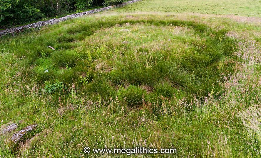
This must rank as one of the most frustrating monuments to record that we have visited! The undergrowth at the site was not really that dense, but the low lying nature of the monument made it invisible from only 100m away. If it were not for the differential plant growth caused by the ditch gathering moisture, our photos would have been of featureless patches of grass.
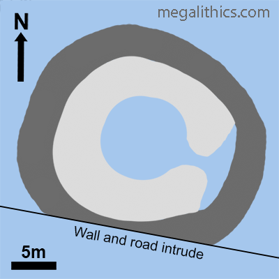
This is quite a small henge, the bank has an outer diameter of 27.3m measured through the centre along the causeway ESE-WSW, but the overall profile is not a true circle, it appears to be flattened NE-SW but a large part of the bank has been destroyed by the building of a wall, so an accurate N-S measurement of this is impossible. The central area has a diameter of 9.5m N-S, and again, this is not a true circle. The ditch varies in width but was 6.3m wide ESE-WSW measured from the edge of the central space to the peak of the bank. The bank is 1.3m taller than the central space and the ditch 1.2m lower than it.
It is difficult to see how a monument this small, with no upstanding elements, has survived in an area of intense agriculture. The New Statistical Account is full of references to whole intact circles of large stones being removed to facilitate ploughing, so fortune has really smiled upon Contin.
The Contin henge has an unusual feature in that its bank is not interrupted to allow access to the causeway. The causeways are interpreted as being access routes to the central space and there is usually a gap in the bank corresponding to their location, almost all henges show this feature, even those with multiple causeways. Woodham (3) spotted this unusual feature in his survey of four local henges, and theorised that it was a local trait as two other henges (Culbokie and Cononbridge) in his study also displayed this feature.
Many henges appear to have been positioned with the proximity of local water sources in mind, and Contin is sited on the eastern shore of Loch Achilty, indeed, the loch is less than 100m away and would be visible from the site if it were not for the trees which line the nearby road.
We could find no references to excavations at Contin. Woodham's plan shows what seems to be the path of a trench running through the northern side of the monument, but he makes no reference to this in his paper. Also we could find no further details of the "empty earthen jars" unearthed by the Barrow Diggers mentioned in the New Statistical Account.
Contin is only metres away from a minor road off the A835, you can literally stop there and look over the wall to view the monument, but with so little to see, this is one for the diehard prehistory fan only.
1.
Sinclair, J.,
The New Statistical Account of
Scotland, 14, p.237-8,1834-35,
Edinburgh.
2.
Skene, J., Proceedings of the Society of Antiquaries of
Scotland, 2, ff. 324, Pl.VII,1822.
3.
Woodham, A. A.,
Proceedings of the Society of Antiquaries of
Scotland, 41, p.73-8,1952-3.