|
|
|
More Pics - External |
|
|
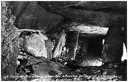
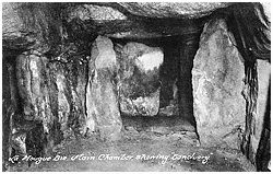
More Pics - Internal |
|
|
|
Virtual Tours |
|
|
|
3D Vision |
|
|
|
Infrared |
| 49' 12.0234" N, 2' 3.8184" W (GPS 99min, passage entrance) Jersey grid 683504* | |
| Visited June 2005 *estimated, Jersey map datum not available for GPS. |
![]() The stone numbering
scheme used throughout our La Hougue Bie coverage is that of Rybot (1).
The stone numbering
scheme used throughout our La Hougue Bie coverage is that of Rybot (1).
Click the icon above to view our interactive numbering console.
 La Hougue Bie is a spectacular cruciform Passage
Grave with a largely intact mound situated 2.5km west of Gorey on the Island of Jersey. It is a member of a group of similar monuments known as Armorican Passage Graves,
with a distribution covering the Channel Islands and Brittany, with a
particular concentration in the department of Morbihan in southern Brittany.
La Hougue Bie is a spectacular cruciform Passage
Grave with a largely intact mound situated 2.5km west of Gorey on the Island of Jersey. It is a member of a group of similar monuments known as Armorican Passage Graves,
with a distribution covering the Channel Islands and Brittany, with a
particular concentration in the department of Morbihan in southern Brittany.
Armorican Passage Graves (APGs), are impressive monuments, both in size and construction, but La Hougue Bie must be the most spectacular example in existence. In terms of sheer size, La Hougue Bie currently dwarfs the competition. The two nearest rivals are the mainland monuments of Gavrinis and Petit Mont , the primary cairns of these APGs contained about 3000 cubic metres of material each, the primary cairn at La Houge Bie was more than twice this size at 6300 cubic metres (2).
After the addition of the primary and secondary terraces, the La Hougue Bie cairn contained over 9000 cubic metres of material, easily beating the final stage 5000 cubic metre volume of Gavrinis; Petit Mont, however, is estimated to have had a final stage volume of 15000 cubic metres. Fortunately the addition of the primary and secondary terraces was not the end of the story at La Hougue Bie, the entire mound was later covered with a layer of soil producing the seemingly earthen mound that we see today. We could not find any published estimates for the volume of the present mound, but the figures for a truncated cone 58m in diameter at ground level, 12.2m tall, with a summit diameter of 20m (the current dimensions), gives a volume of 15700 cubic metres. Admittedly this calculation does not allow for the forecourt void or the passage grave internal volume, but the present volume of the Petit Mont cairn is estimated to be only 10000 cubic metres, so the mound at La Hougue Bie is currently the largest surviving for an APG.
The cairn at La Hougue Bie is also the tallest known, at 12.2m it towers over its nearest rival, Gavrinis, a mere 8m high. La Hougue Bie also has the longest internal construction at 18.6m, with Gavrinis again the nearest rival at 17.0m, followed by another Jersey APG, Faldouet, at 14.0m (3).
In terms of internal structure, La Hougue Bie is unique among the APGs, its chamber has a cruciform layout, with two opposed lateral chambers and a terminal chamber. Lateral chambers are a particular feature of Channel Island passage graves, being represented in one third of these monuments, they are however very rare on the mainland, with only five examples being known and only two of these having opposed chamber arrangements (4). It is the presence of the terminal chamber that really sets La Hougue Bie apart, no other surviving APG has a comparable structure.
If size and structural rarity were not enough, La Hougue Bie is unrivalled in its state of preservation, there is a good possibility that the passage grave remained sealed and intact until the 1920's. As there is radiocarbon dating evidence to suggest that the passage was sealed around 3000 cal. BC, this would mean that the chamber lay intact and unvisited by humans for around 5000 years.
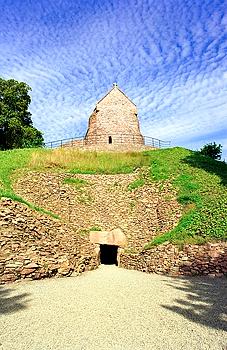
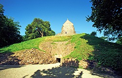
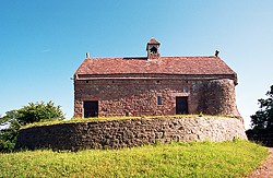
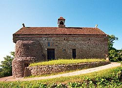
Although a much later construction, an unusual and visually striking feature at La Hougue Bie is the medieval chapel perched on the summit of the mound. The original fabric of the chapel dates from Norman times and several features of its present construction may hint at possible early knowledge of the passage grave beneath.
 Since the beginning of the twentieth century interest in
the prehistoric remains of the Channel Islands had been growing steadily, and
this became particularly intense around the 1920's. There had long been
speculation that the mound at La Hougue Bie was in fact a barrow, and when the
Société Jersiaise took possession of the site in 1924 no time was lost in
exploring this possibility.
Since the beginning of the twentieth century interest in
the prehistoric remains of the Channel Islands had been growing steadily, and
this became particularly intense around the 1920's. There had long been
speculation that the mound at La Hougue Bie was in fact a barrow, and when the
Société Jersiaise took possession of the site in 1924 no time was lost in
exploring this possibility.
Excavation of the mound began on the 3rd of September 1924 with the digging of a trench into the eastern side of the mound (5). By luck or design, the dig was started in best possible area for the discovery and entry of the passage grave, after only ten days of digging the original entrance was found and the passage entered. Exploration of the passage grave was not to straightforward however, it was discovered that the passage could be entered for only a short distance as two of the roof slabs had collapsed, and a roof fall blocked the way. It was thought that any attempt to remove the slabs and the in-fallen cairn material would result in a major collapse, so it was decided to dig down through the mound to the fallen capstones and to consolidate the roof in that area with concrete. With the roof of the passage strengthened, the remainder of the passage, and then the chamber itself was entered and explored.
 When the investigations of 1924 were completed a concrete
tunnel was constructed into the mound to allow public access to the passage grave.
Electric lighting was installed, and in April of 1925 the tomb was opened to the
public, who could explore its mysteries for the princely sum of sixpence.
When the investigations of 1924 were completed a concrete
tunnel was constructed into the mound to allow public access to the passage grave.
Electric lighting was installed, and in April of 1925 the tomb was opened to the
public, who could explore its mysteries for the princely sum of sixpence.
This was not however, the end of discoveries by excavation at La Hougue Bie. In 1991 a series of excavations was commenced that was to continue until 1996, (6) these were designed to discover the chronology of the development of the cairn and passage grave, to investigate a suspected second internal structure, and finally to restore the original facade of the passage grave if possible.
At the end of the 1920's excavations entry to the passage grave was via a concrete tunnel into the mound with an axis canted northwards to the passage axis, it was later discovered that this off centre alignment had served to hide an important feature of the passage grave's construction for many decades, more of which later. In the new excavations, this tunnel was removed and the entire forecourt area was examined along with sections of the cairn itself south of the entrance. The excavations were guided by the results of a geophysical survey involving resistivity and ground penetrating radar techniques.
The new investigations revealed that the passage had originally been shorter, and that the cairn itself underwent several modifications over time. Lastly, and perhaps most importantly for the modern visitor, the original funnel shaped forecourt of the tomb was revealed and restored, massively enhancing the appearance of the monument.
Much of the information shown here regarding the mound, the forecourt structure, and the entrance to the passage grave was revealed in the course of these later excavations.
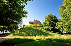 Today,
the mound at La Hougue Bie is 58m in diameter, has a height of 12.2m, and covers a ground area of almost 2400 square metres. Apart from the exposed
walling of the restored forecourt area, it appears to be a simple mound of earth, but
excavation was to reveal its true nature and history.
Today,
the mound at La Hougue Bie is 58m in diameter, has a height of 12.2m, and covers a ground area of almost 2400 square metres. Apart from the exposed
walling of the restored forecourt area, it appears to be a simple mound of earth, but
excavation was to reveal its true nature and history.
The first, or primary cairn built at the site was smaller than the mound we see today, it is actually buried within the larger mound. During the excavations of the 1990's only a small area of the primary cairn margin was exposed, and from this a diameter of 38m was estimated (7). The excavations also showed that the primary cairn had a core of rock rubble faced with carefully laid irregular stone blocks, it was built directly on the old ground surface and was comprised entirely of rock, earth was not used in its construction. The chamber and first, shorter version of the passage were housed within the primary cairn, but these may not have been the first megalithic structures at the site. One of the orthostats in the north wall of the passage grave chamber bears rock art in the form of many cupmarks, but this stone was inserted into the passage grave structure in a way that buried most of these markings out of sight within the wall. Decorated stones found in similar situations in other megalithic monuments have been shown to be the remains of earlier structures reused in the construction of the structure that replaced them. It may be that the cupmarked stone was part of an earlier monument at La Hougue Bie, which perhaps prompted the passage grave builders to select this location. Unfortunately any remaining traces of an earlier monument are now beyond reach, buried forever beneath the huge mound we see today.
In terms of chronology, the primary cairn is thought to have been constructed between 4000 and 3500 cal. BC (8). A relatively short time after this the passage of the grave was extended, and the architecture of the cairn was modified to absorb this new element. In addition to the cairn alteration, a terrace was built around the entire circumference of the cairn, this was composed of an earthen platform retained on its outer side by stone revetment. This would have given the mound a "stepped" appearance, a feature found at many mainland APGs.
Some time later, but still within the 4th millennium, a second terrace was added over the first. This secondary terrace had a similar earth core and stone facing, excavation showed that its addition increased the diameter of the cairn to 52m.
Within around 3500 to 3000 cal. BC a shallow ditch was dug around the edge of the secondary terrace, it was about 0.5m deep and about 4m wide. The ditch was found around all of the secondary terrace exposed in the 1990's excavations, and it presumably runs around the whole mound, the 1924 excavations had destroyed any traces of this feature that existed in the forecourt area itself.
Around 3000 cal. BC the entrance to the passage grave was blocked and the forecourt area filled with rubble up to a depth of 2 metres. During the later excavations, a large area of the stone facing of the secondary terrace south of the forecourt was found to have been stripped away, it is speculated that this may have been the source of the material used to block the forecourt.
The final prehistoric alterations to the cairn took place around 2900 to 2500 cal. BC when the external features of the cairn, the terraces and the forecourt, were covered over with a thick layer of soil. The cairn then took on the appearance of the simple conical mound of earth we see today.
The mound then seems to have been ignored until the arrival of the medieval chapel builders.
Examining the dates above, the monument seems to have been built and used by humans in one way or another for at least 600 years, and possibly as long as 1500 years.
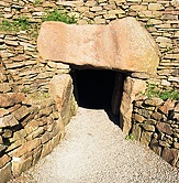
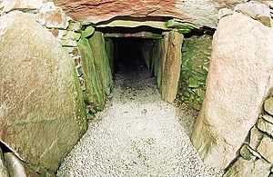
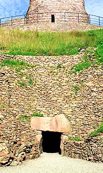
The entrance to the passage grave is situated on the eastern side of the cairn and now consists of a trilithon portal in a funnel shaped forecourt constructed from dry stone walling. When the 1924 excavations were concluded, entrance to the passage grave was via a concrete and brick tunnel and none of the present forecourt and facade was visible. The restoration and stabilisation of the forecourt area was carried out at the end of the 1990's excavations, resulting in the magnificent structure visible today. The entrance portal pictured above was also restored.
At the beginning of the 1990 excavations the northern (right) end of the entrance lintel was supported by dry stone walling, this was found to have been constructed during the 1924 excavations. In 1996 the walling was removed and the entrance area investigated, sockets for two stones were revealed, the outermost of which had obviously supported the northern end of the entrance lintel. Three large stone fragments that had been used in the foundations of 1924 walling are suspected to be the remains of the interior stone, as once reassembled, they would fit the gap perfectly, no trace of the outer orthostat was found. It is not known when the outer stone was removed, it has been suggested that it was done as part of the final sealing of the tomb, the lintel smashing the internal stone as it fell (9). There is some tenuous evidence that suggests that the tomb entrance may have been exposed in medieval times, so it is also possible that the damage may have occurred then. Two new stones of suitable material were selected and used to create the entrance portal structure that we see today.
 |
 |
Another consequence of the removal of the1924 wall was the discovery of a section of primary cairn facade behind the locations of the two missing stones. The photo above left shows the two new stones on the right with the exposed primary cairn between them. This was an important discovery as it meant that the passage had at one time been shorter than its present length. It is thought that the passage was extended by 2.4m very soon after construction, the primary cairn being enlarged to accept the extended passage, the original facade was then hidden by the new facade.
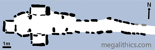
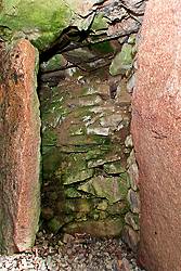
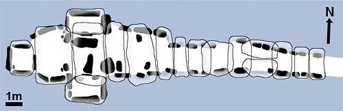
The interior of the passage grave has a cruciform layout, with its main axis aligned almost exactly east-west. The passage element of the grave runs for 9m and is 0.9m wide at the entrance, widening to 1.32m just before it joins the chamber. The chamber is also 9m long and is 3.06m across at its widest, it has an asymmetrical shape, the southern wall being almost an extension of the passage wall, whilst the northern wall bulges out to provide most of the extra width found in the chamber area.
The excavators of 1924 noted that the floor of the entire monument was covered with a layer of "sea gravel" some 2 to 4 inches thick. The floor of the most western section of the chamber had received special treatment, which is described later.
The walls of the passage and chamber are constructed of large orthostats inter-filled with dry stone walling. The passage is mainly roofed with transverse slabs, but one section was roofed by two slabs (Nos. 37 and 38), placed parallel to the passage axis, they rested upon the transverse slabs on either side.
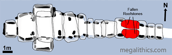
This variation in roofing method appears to have been unwise, as these are the two stones that failed and fell in blocking the passage. The chamber area is also roofed with transverse slabs, although these are much larger than those of the passage, the biggest weighing in at an estimated 20 tons. One of the chamber roof slabs (No. 66) shows a rather disturbing crack, and this stone is now supported by a modern granite pillar for safety reasons.
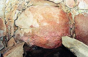
Not all of the roof slabs bear directly on the wall orthostats, in places the dry stone walling supports the roof slabs directly, and in the case of the largest chamber roof slab (No.69, an estimated 20 tons), corbelling is employed. The photo above shows this feature which is most extensively employed on the southern (left) side.
The chamber area has a complex structure and is divided into four areas by large orthostats, these stand within the chamber space and are not part of the walling.
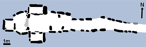
The most curious of these is a set of three stones standing just after the chamber begins (Nos. 11, 13, 43). Two of these (Nos. 11 and 13), stand by the southern wall and the other stands roughly halfway between them on the northern wall. Although there is a clear path between them, these stones form a kind of zigzag "devil trap" and they are responsible for demarcating three of the chamber areas. There is a small irregular space between the end of the passage and the two most eastern stones of the set (area 1), there is a triangular area enclosed by the three stones (area 2), and then there is the main section of the chamber (which is itself further subdivided), beyond the two most western stones of the set (areas 3 and 4).
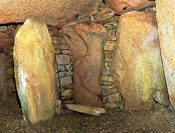
Within the triangular space (area 2) marked by the three stones, the two southern stones flank two of the wall orthostats, and one of these (No. 12) is quite effectively screened from view, either from the passage or the other chamber areas. The screened stone (centre of photo above) has a curious organic "sculpted" form, it reminded us of the trunk of a tree, and we wondered if it had been specially selected for its location in this "niche" as none of the other orthostats in the passage grave had a similar appearance.
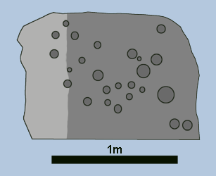
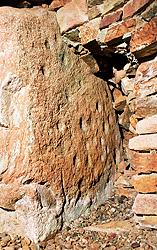
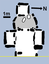
To the West of the three stone arrangement the chamber is divided into two sections (areas 3 & 4) by two jamb stones, one on either side chamber. The eastern section, area 3, contains the two lateral chambers which face each other, their entrances aligned. The chambers are rectangular and their floors are raised above that of the chamber, being retained at the the entrances by sill stones. The eastern side slab of the northern lateral chamber (stone 41) has at least 24 cupmarks on its eastern face, being the only definite rock art to be found in the structure.
 |
 |
 |
Click for larger images.
The position of the cupmarks was originally puzzling as the location of this stone meant that nearly all of the rock art was buried by the chamber wall and therefore hidden from view. It is now thought likely that the decorated stone is actually part of an earlier megalithic structure which has been reused in the construction of the passage grave, its rock art therefore irrelevant to the new structure. Such reuse of decorated stones has been seen at other megalithic monuments, but in this case it is not possible to tell if the stone was part of a structure at the site predating the passage grave, or if it had been transported here from a distant site. The walling in the chamber has been removed next to the stone so that visitors can see most of the decorated surface.
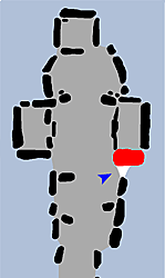
In the original investigations of the 1920's three large slabs were found on the floor of the chamber in the vicinity of the lateral chambers (see map above), two of these were interpreted as being sealing slabs for the entrances of the lateral chambers, they have since been removed from the passage grave. The third slab was thought to have been used as a sill stone for the front part of the western section of the chamber (area 4), this area has been suggested to have been the focus of ritual activity within the passage grave and is known as "the sanctuary". This slab was "reinstated" in its "original" position and can be seen in the chamber today. It should be noted that the presumed original locations and uses of the three slabs was based purely on speculation by the 1924 excavators.
 |
 |
The semicircular area behind the separating orthostats and in front of the terminal chamber, the "sanctuary", was found have had its floor raised slightly above that of the rest of the chamber. The platform was constructed of rubble covered in a layer of the fine pebbles that floored the rest of the chamber, and when this was excavated, a second layer of pebbles was discovered at the level of the original floor, indicating that the platform was constructed after the initial pebble flooring of the monument had been laid.
The two orthostats which segment the sanctuary area from the rest of the chamber each form a small corner "niche" and within these spaces stood small standing stones or "betyles", each around 30cm tall, two were found in the northern niche, and one in the southern. These diminutive stones were obviously important as their positions mean that they are only visible from the sanctuary area itself and are completely hidden from observers in the passage or main chamber areas. The concept of limiting visibility of the sanctuary betyles is taken to the extreme in the placement of the last betyle discovered in the passage grave. A fourth betyle was found standing in the SW corner of the terminal chamber, it is situated at the point most distant from the passage grave entrance and is visible only to observers actually in the terminal chamber or standing at the entrance. Whatever the function of these tiny enigmatic standing stones, it appears that access, or even sight of them, was deliberately restricted by their placement.
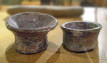
A further indication of the importance of the "sanctuary" area was the discovery of two pottery vessels set within its entrance, one at the foot of each of the segmenting stones. These vessels were of a type known as "vase supports" they are circular in plan and have a shallow dish-shaped upper surface supported by a hollow skirt, which can be waisted or straight (see photo above). These two vessels are significant in that they were the only intact pottery items found in the tomb, although the fragments from at least 19 other vase supports were found scattered in the central part of the chamber. Evidence of burning was found in the bowls of the vase supports, suggesting that they may have been used as lamps to illuminate this area.
A small rectangular cist containing vase support fragments and pebbles was discovered at the rear of the platform and a stone lined pit was found just in front of the terminal chamber entrance, neither of these features are visible today.
At the extreme western limit of the main chamber is located the terminal chamber, in contrast to the wide, low-ceilinged lateral chambers with their raised floors, this chamber is a tall, narrow space, almost like a stone telephone box. The chamber has its own capstone and the rear and sides are formed from single walling slabs, there is a small amount of dry stone fill in the lower north western corner, but the chamber is essentially a stone slab box. The eastern wall of the terminal chamber which divides it from the sanctuary area is provided by another large slab which is offset to the south, forming a narrow entrance at its northern edge.
The original situation of the eastern slab was unusual, the 1924 excavation found it in place but discovered that its lower edge was not socketed, but was supported on the curved surface of a broken and inverted quern, a most unusual foundation. The pebbles of the original floor were found beneath and within the quern, suggesting that the quern, and perhaps also the dividing slab, were in position before the sanctuary platform was constructed. The strange foundation of the dividing slab may have been intended as a pivot to allow precise positioning of this stone when it was set in place, this would be critical for another feature of the passage grave, which we will cover shortly. When the petrology of the stones making up the monument was examined, the dividing slab and its quern foundation had another surprise in store, they were the only stones in the entire monument that were of granite from Mont Mado, an outcrop almost 7km distant.
With unique petrology and unusual placement, the builders of the passage grave obviously thought the dividing slab to be specially significant. A possible reason for this, although suspected for many years, could not be put to the test until the entrance tunnel was demolished and the forecourt area restored - the passage grave had an astronomical alignment to the equinoctial sunrises.
The entire layout of the passage grave was constructed with an alignment to the rising sun on the mornings of the equinoxes in mind. It was discovered that this alignment had been suspected as early as 1949 (10), but because of the tunnel built by the 1924 excavators it could not be directly tested by observation until the restorations of the 1990's. The first observations were carried out around the spring equinox of 1996 by Olga Finch and Peter Bohea (11) and they confirmed the suspected alignment. The exact currency of the display is not known exactly, but it has been established that it is visible for at least three days either side of the equinoxes.
The rising sun's rays first strike the dividing slab of the terminal chamber about 25cm above ground, and 60cm from the northern edge, the beam then tracks north until it enters the terminal chamber itself. After leaving the terminal chamber, the floor of the sanctuary and the eastern edge of the sill stone become flooded with light, the strong reflections from these areas illuminate the entire rear section of the chamber. Finally the shaft of light lowers as the sun rises and the floor of the chamber and passage become bathed in a ribbon of sunlight gradually lengthening towards the entrance. A spectacular display.
There is however another alignment which has caused much speculation concerning possible knowledge of the passage grave in medieval times, this is the position of the window in the ring crypt of the medieval chapel.
When a plan drawing showing the locations of the passage grave chamber and chapel is viewed, a degree of similarity in proportions and size is apparent, as is the rough vertical alignment of the two structures. The most obvious area of difference in the two structures is that their axes differ in alignment by around five degrees.
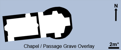
A complicating issue is the presence of a window in the ring crypt of the chapel, this is distinctly off-axis with reference to the chapel, but a line through the axis of the passage element of the Passage Grave runs directly beneath the window. The vertical alignment is even visible externally as the photo below shows.
 |
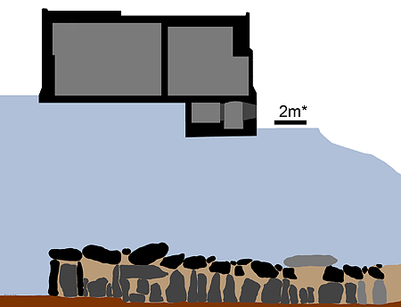 |
*The chapel/passage grave overlay illustrations are based on a diagram from 1925 (5) and the accuracy of this is dubious. By our estimates, the chapel is shown almost 2m too long and the passage grave interior is 0.7m too long, positional accuracy is probably just as reliable, so the illustrations should be interpreted accordingly.
One interpretation of these coincidences is that the passage grave was accessible in the Middle Ages. Note that access to the whole of the passage grave would be required for the dimensions and position of the chamber to have been taken into account during the planning of the chapel, access to the short length of passage in front of the roof fall found in 1924 would not provide this information. The original form of the chapel, probably built in the late 12th century, lacked the rotunda and window seen today, but this building set the ground plan (and axis) for the later versions. If the object was to match the chapel structure with that of the Passage Grave, why were the axes of the two structures allowed to differ by as much as five degrees?
The ring crypt and tomb below the chapel were added by the infamous Dean Richard Mabon in the 16th century, so the unusual off-axis alignment of the crypt window is unconnected to the original choices for the size and position of the chapel itself. It may be that the positioning of the window was arrived at by a much later, completely separate attempt to create a similar equinox (with its Christian Easter connotation) alignment, this time in the crypt itself. The window position and the jambs of the "tomb" entrance allow the rays of the rising sun to penetrate the "tomb" interior on only a few days in spring and autumn. The asymmetrical location of the window, and the way that the southern jamb of the "tomb" opening appears to have been canted to allow light access suggest that this light show was not accidental. So, it may well be that the alignment of the crypt window and the passage grave axis is the result of two independent attempts to achieve similar goals, albeit separated by some five thousand years.
The roof fall in the passage and the fall of the entrance lintel resulting from the removal of the northern support stone would both deny access to the passage grave chamber, so both of these would need to occur in or after the 12th century for entry to the entire structure to be possible then. The later window alignment could possibly have been derived from access to the passage as far as the roof fall, but this presupposes that the lintel support stone was removed in the 16th century or later.
There is no direct evidence for medieval entry of the passage grave, and we think that it is most likely that this did not occur, that the chapel proportions, its position, and the location of the crypt window are all coincidental to the earlier monument's existence.
An ancient monument as important and impressive as La Hougue Bie would not be complete without at least one legend concerning its past, and sure enough, one exists. Like all good legends it tells a tale of bravery, deception, justice, and retribution, and just to make things complete, it involves a Dragon.
A long time ago, a Dragon roamed around the Island of Jersey killing folk and animals, burning down houses and generally breathing fire where it was not wanted. Across the water, news of this terrible beast and its reign of terror spread far and wide, eventually reaching the ears of the Seigneur de Hambye in his lands in Normandy. The brave Seigneur at once set off, traveling over land and sea to do battle with the Dragon. Arriving on Jersey he discovered that although the Dragon ranged all over the island visiting destruction upon the inhabitants, it had made its home in the marshes of St.Saviour. He traveled to the marsh, found the Dragon and immediately entered into single combat with it. The battle was long and strenuous, and the Seigneur sustained many wounds, but eventually he prevailed over the beast, severing its head with a single blow.
After his great ordeal, guarded by his squire, the Seigneur lay wounded and exhausted attempting to gather his strength. The treacherous squire had long coveted his master's wife and his lands , seeing his chance, he slew the weakened seigneur and buried his body in the marsh. The squire returned to Hambye alone, telling how the Seigneur had bravely battled the Dragon, but had been slain by the beast. He then told of how he himself had single-handedly avenged his master, killing the Dragon for once and for all. The evil squire then added that it had been his master's dying wish that he should marry his wife.
Being a good and faithful wife, the Seigneur's widow followed her husband's supposed dying words and married the squire. The squire would have succeeded in his deception, but one night, as they lay together, the squire began to talk in his sleep, and related all of his terrible crime. The lady had the squire brought to trial, where he confessed to his sins and was sentenced to death.
The lady traveled to Jersey and discovered the grave of her husband in St.Saviour, she had the body moved to high ground and caused a huge mound to be raised over it. So tall was the mound, that it was even visible from her Normandy homelands. The mound became known as La Hougue Hambye, and over the years, this became shortened to La Hougue Bie, the name it bears to this day.
There are many different versions of this legend and there have been attempts to identify elements of truth in the story (12), particularly the association with the Paisnel family of Hambye.
 |
 |
The chapel(s) are obviously not part of the prehistoric structure at La Hougue Bie and are therefore outside of our area of interest, so we include only a very brief account of this building here.
The earliest definite records relating to the chapel are from the16th century, although it is almost certain that there was a structure on the site considerably earlier than this, perhaps dating from the12th century or earlier.
The building today is divided into two separate chapels, the Notre Dame in the west, and the Jerusalem in the east, there is also a rotunda and ring crypt beneath the Jerusalem chapel. The building has been much modified over time, access between the two chapels is thought to have been a feature, as is a stairway connecting with the ring crypt. The most extensive modification however, was the chapel's extension and conversion into a private dwelling in the form of a miniature gothic castle.
Known as the Prince's Tower, this fantastic edifice is thought to have been constructed around 1792. There is some confusion regarding the identity of the builder, but the consensus seems to favour Captain Phillipe d'Auvergne, the nephew of the owner of the land, Major-General James d'Auvergne, an officer in the Household Cavalry of George III.
The conversion included a large extension to the north, which comprised a crenellated single storey section used as a dining room, and a two storey octagonal hall/stairway giving access to the newly built upper levels. A large tower was built over the east end of the Jerusalem chapel, it contained a drawing room on its first level and a bedroom on the second, at the top of the tower was a flagstaff and signaling platform, a small stair turret clung to the west side of this tower. The Notre Dame chapel was retained as a private chapel and the Jerusalem chapel was used a library.
 |
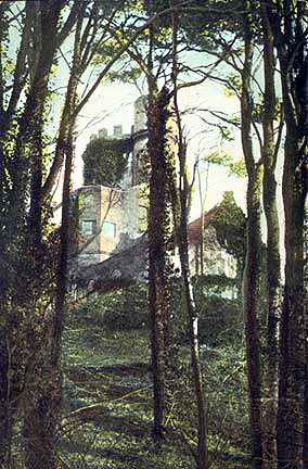 |
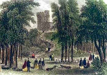
Unfortunately, the two images of the Prince's Tower we could obtain do not show the structure very clearly. The image on the left is a hand coloured engraving taken from J & F Harwood's "Illustrations of Jersey" 1855, and the image on the right is a hand coloured photographic image used as a postcard. In the photo, the octagonal hall/stairway can be seen on the left with the main tower and its stair turret above, the gable far right is the west end of the original chapel. Even these limited views can serve to convey what a whimsically turreted and crenellated gothic confection this structure was.
The fame of this new building spread and attracted many curious people, eventually some time before 1833 the tower and the grounds were opened to the paying public as a visitor attraction. The engraving above shows a scene of people enjoying the Prince's Tower pleasure grounds, complete with peacocks.
It appears that the tower continued to be accessible to the public until the early 1920's, but it was in very poor condition by this time and the tower extensions and additions were demolished in 1924 so that only the fabric of the chapels remained. The chapels were "restored" following the demolition of the Prince's Tower, resulting in the completely segregated two-chapel structure that we see at the present.
La Hougue Bie is situated only 2.5 miles from St.Helier and is open from March 31st to September 4th, 10am to 5pm. You can explore the whole interior of the Passage Grave and chapels and there is an excellent museum at the site with an extensive collection of archaeological finds and exhibits. There are also guided tours, demonstrations, and many other visitor attractions scheduled throughout the season.
Highly recommended!
1.
Rybot N.V.L., La Hougue Bie, 2nd ed,Societe Jersiaise,
Jersey, 1947
2. Patton M., Rodwell W., Finch O., La Hougue Bie Jersey, p106, Societe
Jersiaise 1999.
3. Patton M., Statements in Stone, table 4.3, Routledge,1993.
4. L'Helgouach J., "Les Sépultures
Mégalithiques en Armorique." Travaux du Laboratoire d'Anthropologie de
l'Université de Rennes, 1, 1965.
5. Baal H.J., Godfray A.D.B., Nicolle E.T., Rybot N.V.L., Annual Bulletin of the Societe
Jersiaise, 10, p205-217, 1925.
6. Patton M., Annual Bulletin of the Societe Jersiaise, 26, p424-432, 1995.
7. Patton M., Rodwell W., Finch O., La Hougue Bie Jersey, p112, Societe
Jersiaise 1999.
8. Patton M., Antiquity, 69, p582-586, 1995.
9. Nash G., Annual Bulletin of the Societe
Jersiaise, 27, p491-501, 1999.
10. Taylor J.N., Paper in library of Societe Jersiaise, "Some speculations
upon the purpose and origins of La Hougue Bie", 1949.
11. Patton M., Rodwell W., Finch O., La Hougue Bie Jersey, p120, Societe
Jersiaise 1999.
12. Nicolle E.T., Annual Bulletin of the Societe Jersiaise, 10, p179-204,
1925.